Zendmast (Houtem, Veurne, België)
Foto’s – Info – Meteo – Tips – Nieuws – Geo Info –
Algemene info over de zendmast van Jump Trading
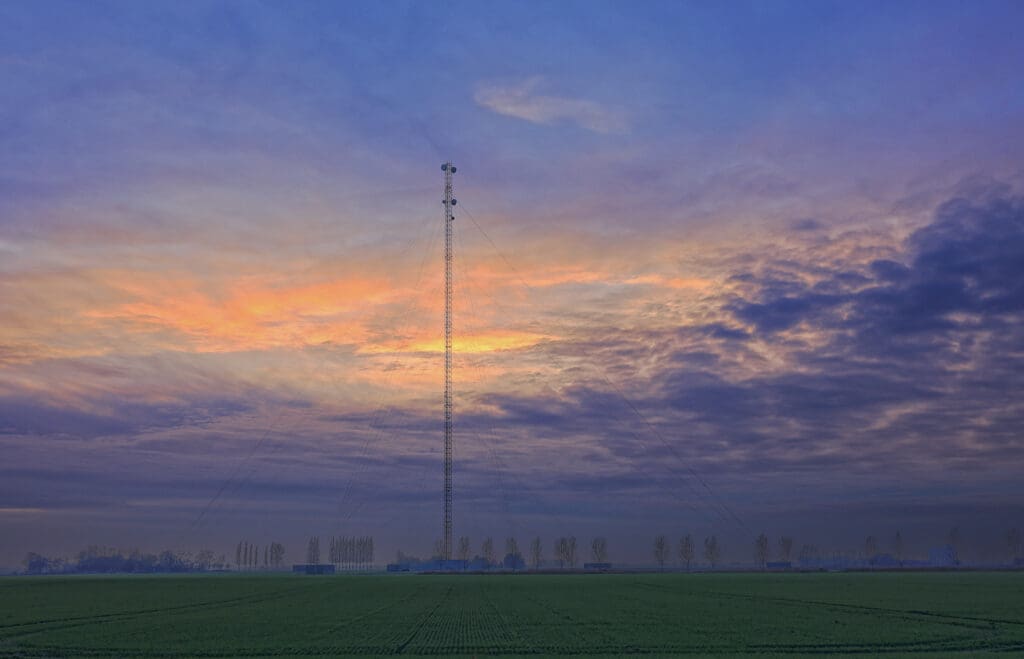
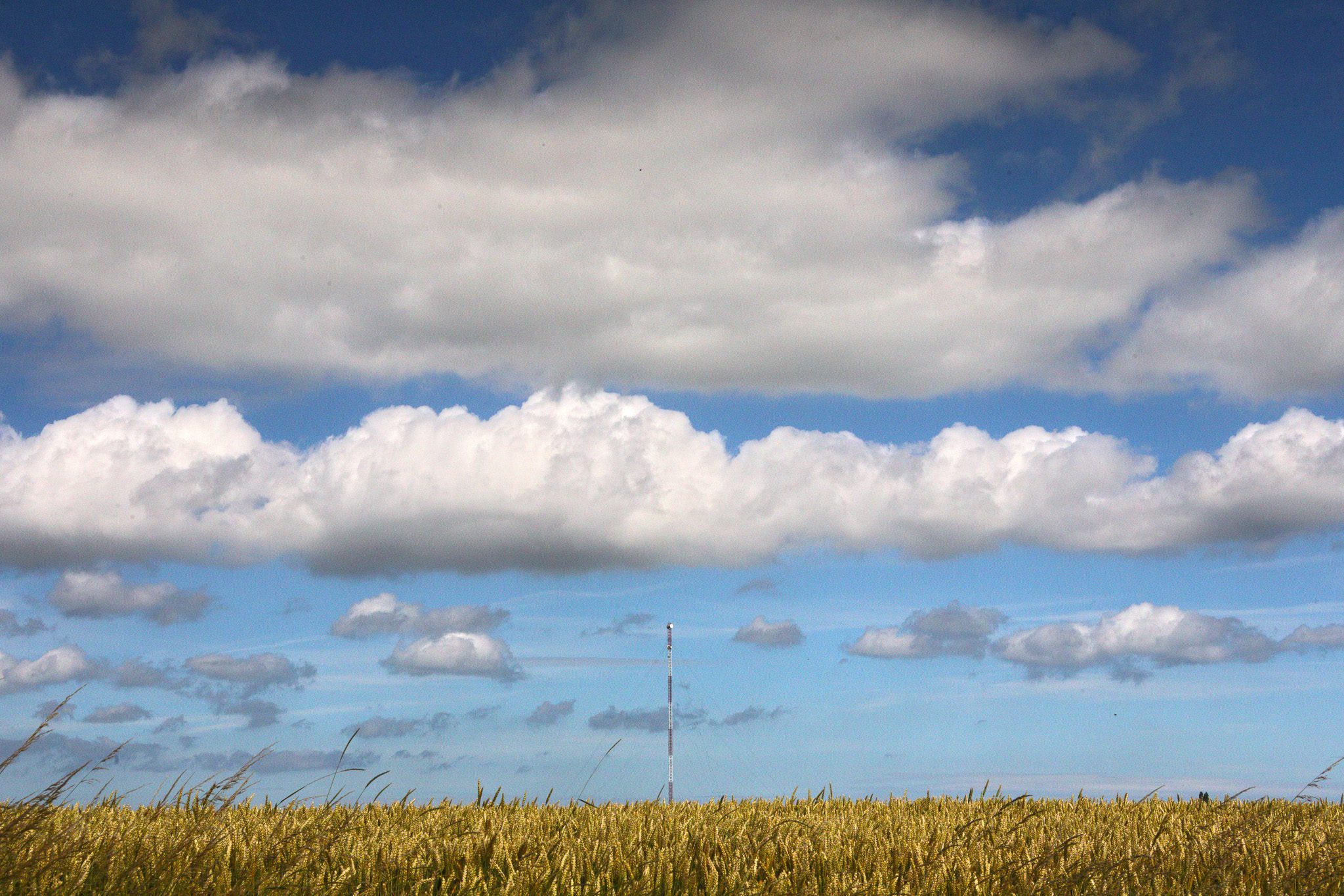
De Zendmast van Houtem is niet “zomaar” de eerste, de beste zendmast. Ze is maar liefst 243,5 meter hoog en sinds 2013 eigendom van het Amerikaanse bedrijf Jump Trading LLC (gevestigd in Chicago). Het terrein 38025/838 SV is 1 hectare, 31 ares 66 centiaren groot.
Zij kochten, via een bedrijf gevestigd in de UK, op 19 december 2012 de toren van het ministerie van Financiën voor 5 miljoen euro. De deal werd wereldkundig gemaakt op 9 januari 2013 zonder evenwel te vermelden wie de koper was. Dat moest toen nog geheim blijven. Het was veel meer geworden dan het initieel goedgekeurde bod van “slechts ” 255.000 EUR voor wat uiteindelijk voor velen slechts een stuk landbouwgrond was.
Het Ministerie van Financiën had de toren verkregen van het Belgische Leger. De zendmast was vroeger een zendtoren voor de NAVO en gekend onder de benaming “HOUTEM RADIO RELAY SITE“. Je ziet hem onder andere in deze inventaris uit 1999 van het Amerikaanse leger vermeld: “Base Structure Report” (PDF bestand). De Amerikanen hadden in 1963 een verdrag afgesloten met het Koninkrijk België om zo’n zendinstallaties te mogen installeren en beheren op het Belgische grondgebied. Een eerste zendinstallatie was toen voorzien in Flobecq. De bouw van de zendmast in Houtem werd vermoedelijk eind 1973 beëindigd. De Amerikanen beslisten echter in 2006 dat er niet langer meer zou worden gecommuniceerd via zenders maar wel via glasvezel. Daardoor was deze hoge zendmast voor militaire doeleinden niet langer nuttig.
De naam van de huidige eigenaar, “Jump Trading”, verraadt het zelf al: de zendmast wordt nu ingezet om via radioverbindingen bijzonder snelle beurstransacties mogelijk te maken in de financiële wereld (meer bepaald tussen de beurzen van Frankfurt en Londen).
Wist je dat… microgolfverbindingen sneller zijn dan glasvezel vanwege 2 redenen:
1) omdat je met rechte verbindingsstukken zit tussen zender en ontvanger. Glasvezels kunnen al eens een ommeweg maken via diverse tussenstations waardoor je wat tijdverlies hebt omdat, door die ommeweg, de af te leggen afstand net iets langer is; en
2) omdat microgolven die door de lucht gaan dit doen met een snelheid van zo’n 300.000 km/s en lichtsignalen in een glasvezel aan slechts ongeveer 200.000 km/s wat uiteraard een zeer groot verschil is 33% trager dus!). Om het even concreet te maken: per 300 kilometer dat het signaal moet afleggen win je afgerond 1 milliseconde, genoeg om je beursconcurrenten voor te zijn. Londen ligt op zo’n 635 km afstand van Frankfurt. De tijdwinst is zo’n 1 milliseconde in één richting, een roundtrip is bijgevolg zo’n 2 ms sneller.
Eventjes terzijde: In een artikel in van De Morgen staat dat in dit concrete geval de tijdswinst 0,000 004 seconden zou zijn: amper 4 microseconden dus. Volgens mij is dit een factor 1000 er naast: 4 milliseconden zou veel realistischer zijn. Wellicht “gazettenpraat”… 😉
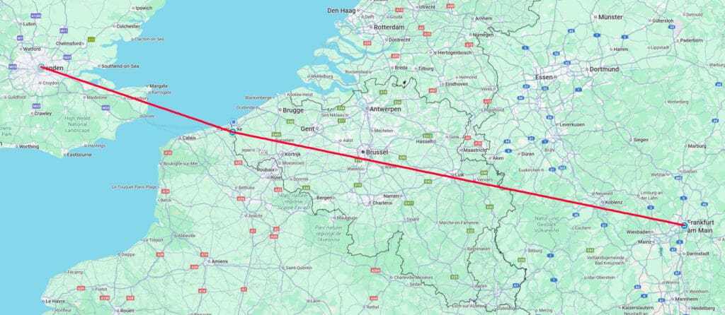
Onderstaande kaart toont je duidelijk aan dat de zendmast heel goed gelegen is tussen Londen en Frankfurt. Waarom ze Londen en Frankfurt niet zonder tussenstation in Houtem verbinden ? Heel simpel: de Aarde is rond. Voor Londen ligt Frankfurt onder de horizon (en omgekeerd). Door een zeer hoog tussenstation te kiezen kan je het probleem van de kromming van de Aarde oplossen. Goed gezien hé? 😉
Echter, dit is het “principe“. Ik stelde het eerst wat vereenvoudigd voor. In werkelijkheid zal de zendmast van Houtem niet in één directe link spreken met Londen, noch met Frankfurt. Dat gebeurt met behulp van diverse andere tussenstops. Dit komt omdat een microgolfantenne maar typisch 40 to 60 km ver kan stralen. In het geval van een hoge mast kan dit worden vergroot tot 70 à 90 km, mogelijks zelfs nog tot 100 km (als die mast nog eens op een heuvel staat, wat in het geval van Houtem niet het geval is: de polders liggen daar zelfs net iets onder de zeespiegel). Te kort dus om Londen of Frankfurt vanuit Houtem in één keer te bereiken. De totale afstand Londen-Frankfurt bedraagt zo’n 650 kilometer. Er zullen dus meerdere tussenstations moeten gebruikt worden. De zendmast van Houtem is slechts één schakel in een veel grotere keten die de twee beurzen met elkaar verbindt.
Nog een weetje: Microgolven hebben een golflengte van 1 m (bij een frequentie van 300 MHz) tot 1 mm (bij een frequentie van 300 GHz), d.i. UHF, SHF en EHF.
Bedenk ook nog even dit: hoe ver bevindt zich de horizon wanneer iemand op x meter boven het Aardoppervlak staat? Welnu:
afstand tot de horizon in km = 3,57 x vierkantswortel (hoogte in meter).
Voor de zendmast van Houtem, die bijna 244 meter hoog is, bekomen we een afstand tot de horizon van 56 km. Weet dat je niet àchter de horizon kan kijken. Stel dat de andere communicatiemast, de ontvanger, ook zo’n 244 meter hoog is, dan kun je in theorie een afstand overbruggen van maximaal 2 x 56 = 112km. In rechte lijn ligt Londen op 201 km van Houtem (Frankfurt zelfs op minstens 350 km) , dus in één keer is dat gewoon niet te bereiken (door de kromming van de Aarde dus en zelfs bij antennes die 244 meter hoog zijn). Je moet dus andere tussenstations er bij betrekken. Zo zit het verhaal écht in elkaar. 😉
We betreden hier het domein van de zogeheten “flitshandel” of ook nog “High Frequency Trading” (afgekort als HFT). Lees hierover meer in dit VRT-artikel of Knack-artikel. De flitshandel kwam in een negatief daglicht te staan via het boek “Flash Boys” van voormalig obligatiehandelaar Michael Lewis.
De zendmast in Houtem is een “guyed mast” — dat wil zeggen: een hoge metalen toren die gestabiliseerd wordt met 48 staalkabels (ook wel “guy-wires” genoemd) die in de grond verankerd zijn. De mast is onderaan smal: alles rust op een ring, met een doormeter van amper 20 cm, op een betonnen blok. We telden 4 keer 2, dus 8 ankerpunten: dit zijn zéér grote betonnen blokken. Per ankerpunt zijn er 6 tuikabels. Deze blokken gaan tot 15 meter diep in de grond wat ook nodig is gezien de natte ondergrond. De Moeren waren ooit eens moerasgebied, nadien weliswaar grotendeels drooggelegd, maar toch.
Naar verluidt zou de zendmast origineel zelfs nog zo’n 30 meter hoger geweest zijn: 274 meter in totaal. Deze mast staat met zijn huidige 244 meter nu op de 5e plaats van de hoogste zendmasten van België (FR – EN). Slechts 4 zijn dus hoger.
Wist je dat… op 30 augustus 2025 deze mast nog in het nieuws kwam toen een 17-jarige jonge Fransman tot op 180 m hoogte de zendmast inklom? Lees er op de website van HLN meer over.
Nieuwsbrieven
Bezoekerstips
Algemene tips:
1) zoekt U naar andere bezienswaardigheden in de buurt, raadpleeg dan onze Toeristische kaart van Top.Vlaanderen.
2) U kan onze overzichtslijsten raadplegen: per categorie ( bijv. tijdslijn, grootte, …) of per regio
3) U kan ook altijd de lokale toeristische diensten raadplegen :
Veurne, West-Vlaanderen, Vlaanderen, België: | ||||
| Onze info | ||||
| Bovenliggende toeristische regio's: | ||||
| Onze info | ||||
| Onderliggende regio's: | ||||
| Onze info | ||||
Tip 1: De zendmast kun je uiteraard niet beklimmen. Wil je een mooi uitzicht over de streek, dan kun je daarvoor bijvoorbeeld terecht bij de Sint-Niklaasktoren van Veurne en de IJerztoren in Diksmuide.
Tip 2: Hou je van molens, weet dan dat er 3 molens zijn niet zo ver van deze zendmast vandaan: de Noordmeulen (Hondschoote, Frankrijk), de Sint-Karelsmolen en de Sint-Gustaafsmolen (beiden in De Moeren, België).
Geografische informatie
Adres: Reigersstraat , 8630 Veurne, West-Vlaanderen, Vlaanderen, België
Geografische coördinaten:
– Google Maps: Latitude = 51.010525 – Longitude = 2.578152
– Open Street Maps: Latitude = 51.010525 – Longitude = 2.578152
– Altitude h = -2 m
Aanduiding van de zendmast van Jump Trading op:
Toeristische kaart van Top.Vlaanderen – Google Maps – OpenStreetMap.
Route naar de zendmast van Jump Trading: Route via Google Maps
Meteo

 20°C
20°C
| Day | Condition | Temperature | Precipitation | Rain Chance | Wind | Humidity | Pressure |
|---|---|---|---|---|---|---|---|
|
Today
21:00
|
lichte regen
|
17° | 20°°C | 0.37 mm | 37% | 28 Km/h | 91 % | 1022 mb |
|
Tomorrow
21:00
|
 bewolkt bewolkt
|
16° | 19°°C | 0 mm | 0% | 17 Km/h | 86 % | 1027 mb |
|
ma jun 26
21:00
|
bewolkt
|
15° | 18°°C | 0 mm | 0% | 26 Km/h | 89 % | 1026 mb |
|
di jun 26
21:00
|
 onbewolkt onbewolkt
|
16° | 19°°C | 0 mm | 0% | 19 Km/h | 92 % | 1024 mb |
|
wo jul 26
21:00
|
onbewolkt
|
16° | 19°°C | 0 mm | 0% | 36 Km/h | 92 % | 1026 mb |
| Hour | Condition | Temperature | Precipitation | Rain Chance | Wind | Humidity | Pressure |
|---|---|---|---|---|---|---|---|
|
Today
03:00
|
lichte regen
|
18° | 18°°C | 0.37 mm | 37% | 15 Km/h | 91 % | 1016 mb |
|
Today
06:00
|
 licht bewolkt licht bewolkt
|
19° | 19°°C | 0 mm | 0% | 17 Km/h | 90 % | 1017 mb |
|
Today
09:00
|
onbewolkt
|
19° | 19°°C | 0 mm | 0% | 24 Km/h | 87 % | 1020 mb |
|
Today
12:00
|
licht bewolkt
|
20° | 20°°C | 0 mm | 0% | 28 Km/h | 86 % | 1021 mb |
|
Today
15:00
|
half bewolkt
|
20° | 20°°C | 0 mm | 0% | 28 Km/h | 80 % | 1021 mb |
|
Today
18:00
|
licht bewolkt
|
18° | 18°°C | 0 mm | 0% | 25 Km/h | 83 % | 1021 mb |
|
Today
21:00
|
 onbewolkt onbewolkt
|
17° | 17°°C | 0 mm | 0% | 24 Km/h | 87 % | 1022 mb |
|
Tomorrow
00:00
|
 licht bewolkt licht bewolkt
|
17° | 17°°C | 0 mm | 0% | 12 Km/h | 86 % | 1023 mb |
Internet informatie over de zendmast van Jump Trading
Wikipedia informatie over:
– Flitshandel / High Frequency Trading (HFT) (NL – FR – EN)
– Zendmast (NL – FR – EN)
– Microgolf (NL – FR – EN)
Artikel over de geschiedenis van de Moeren en de vroegere militaire zendinstallatie: artikel van 26 maart 2019 “4 – Les Moëres English Version” door Alexandre Laumonier. In januari 2019 verscheen zijn boek met als titel “4” over de radionetwerken gebouwd voor HFT (112 p. ISBN 978 293 0601 36 6).
Website met alle antennes van België vermeld (inclusief alle conformiteitsattesten): zendmast.be . Enkel publieke mobiele operator-antennes staan daarop vermeld, dus niet deze zendmast van Houtem.
Dienst van Toerisme “Visit Veurne”:
Website – Facebook – Instagram
Toerisme Westhoek (Westtoer)
Website – Facebook – Instagram
Onze foto’s over de zendmast van Jump Trading
Onze foto’s, video’s, … zijn allen (c) 2004-2026, Top.Vlaanderen, België. Ze mogen niet “zomaar” worden overgenomen of gebruikt. Wil je ze gebruiken voor een of ander project, contacteer ons vooraf en we kijken hoe we kunnen samenwerken. Wil U uw eigen toeristische attractie, B&B, vakantiewoning… laten fotograferen door ons, dat kan ook. Neem hiervoor contact met ons op via ons Contactformulier .
Foto’s van het bezoek op 28 november 2025


Foto’s van het bezoek op 22 november 2025
Klik op een van de onderstaande foto’s om de fotocarrousel op te starten…


Disclaimer: Alle informatie die op top.vlaanderen wordt gepresenteerd werd met de grootste zorg samengesteld. Ze wordt ook regelmatig nagezien. Indien U opmerkingen heeft, fouten ziet, aanvullende informatie hebt, enzovoort… contacteer ons dan via ons contactformulier. Wij zijn niet verantwoordelijk voor mogelijks foutieve of onvolledige informatie.